|
|
"A comprehensive, collaborative elections resource."
|
Jean-Talon - History
 | Riding DETAILS |
|
|
| Parents |
> Canada > Québec > QC National Assembly > Jean-Talon
|
 |
Raw Vote Total:
Percentages:

|
| Website | |
| Established | 00, 0000 |
| Disbanded | Still Active |
| Last Modified | Monsieur February 21, 2007 12:32pm |
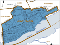
| Description | Jean-Talon contains that part of Quebec City bounded by: St-Sacrement Avenue, Coteau Ste-Geneviève, the east limit of the land of the École St-Joseph-de-St-Vallier, Chemin Ste-Foy, Avenue des Érables, Grande Allée Ouest, Grande Allée Est, the fortification wall, the cliff, the boundary of the towns of Sillery and Quebec City, the St. Lawrence River, Pierre-Laporte Bridge, Henri-IV Autoroute (73), Chemin des Quatre-Bourgeois, Autoroute du Vallon (740), boundary of the towns of Ste-Foy and Quebec City and Autoroute Charest (440).
Mother Tongue Breakdown:
Anglo: 3.1%
Franco: 92.6%
Allo: 4.3%
1995 Sovereignty Referendum: YES - 50.02%
NO - 49.98% |
|
Redistricting: Light Green=Added Territory, Red=Removed Territory, Dark Green=Kept Territory
| |
| No Map In System
| |
|
[Download as CSV]
|